I turned up for my days instructing a little after 10am, and settled down in the clubhouse to await the rest of the duty crew. Ron Sanders showed up to tow, and Ross Anderson was around doing something to his microlight.
We pushed the power planes out of the hangar and moved the Astir out. It was wet, windy, and looked like it wasn't going to get any better, so I thought the Bocian would be better off dry.
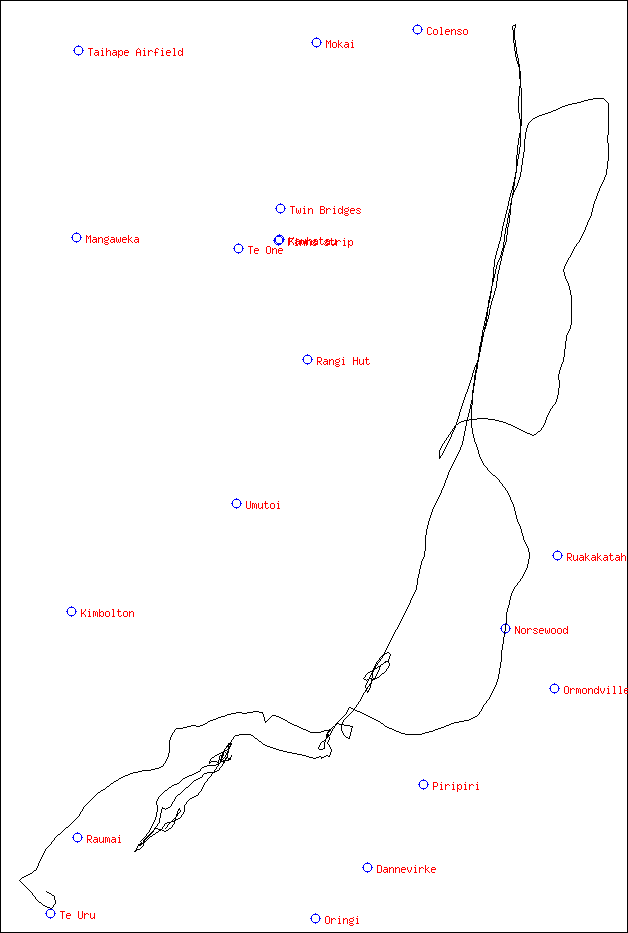
The westerly was blowing steadily, and the forecast was for it to continue, along with occasional showers, all day. The cloud was around 3000ft on Whariti, and went up to maybe 4000ft, then back down over a half hour or so.
Ross was interested in a ridge flight, but wanted to wait till conditions improved. They didn't. After an hour or so he suggested that he'd go if we split the cost of the tow. I'm always keen for some extra outlanding practise, so I agreed.
Ross Perry had shown up to look at the microlight too, but he wasn't convinced that getting the Kestrel out was a good idea. He helped us get out to the launch point and ran our wing though.
Ron gave us a fast tow to 4000ft near the ridge. Ross was flying and took us along in front of the cloud in gentle pressure wave. We stayed around 4000ft for a while, gently gaining and losing a few hundred feet, but always around 4000. We ran as far north as was comfortable, I guess around 5k short of Umutoi, then back south. Cloud was fairly dense, and care was needed to keep clear while staying up.
We dropped down and had to start working hard to stay up. I think we fell down when Ross was on the cellphone. The ridge wasn't working that well down low, and it took a while to find somewhere to get back into the easy lift in the pressure wave. At 2500ft we were looking a little concerned and had several strips picked out as we scratched along just north of Whariti. Some bit were working nicely though, so we were able to get back up to 4000 or so.
We had discussed going over the ranges into the wave, helped along by Ross talking to Ron on the cellphone and getting told that a lennie was visible on the other side of the ranges. As we got to just shy of 4500ft opposite Dannevirke I spotted a gap in the cloud, so we went for it. The ranges are narrow there, just one mountain wide. It's very steep on the eastern side, so as soon as you're through you're out over flat land.
We crossed at 4000ft, going along at 80 or 90 knots with 15 to 20 knots tailwind. As soon as we crossed we were in 8 to 10 knots down. The east was under extensive cloud cover with a 3500 to 4000ft base. There were a few wispy clouds in front of us a couple of kilometers ahead. They were on a direct line to Dannevirke airfield, so they were the first port of call.
Sure enough there was some gentle rotor there and enough lift to get us established. Hardly deserved the description of 'rotor' though. This produced 2 to 4 knots till 6000ft, when we got 4 to 10 knots. From here on we got 4 to 10 knots whenever we stayed in the wave. Ross got out the cellphone and started reminding people what the vario sounds like when it's happy.
Once we got high it was clear were the foehn gap was and we could just trundle along the leading edge of the primary. The lennie was there when we first got up, but dissapeared. All we had was a blanket of cloud with the clear foehn gap, then another gap behind that where the secondary was.
We ran north till the gap closed in and we couldn't get any further without crossing solid cloud. This was up near the edge of Napier airspace, so we went went back south. There where only glimpses of the towns, so although we always had clear air under us navigation wasn't easy. Without a GPS (we both had GPS) you would be easily confused about your position. The mountains were hidden in cloud so even they couldn't be used as landmarks.
Ross had his GPS set to statute miles, and mine is set to nautical. This caused me some confusion. He was quoting speeds and distances sufficiently different to mine to cause me to doubt my GPS. Or his, but I wasn't sure which. He was also using statute miles per hour to judge windspeed, so he was getting 10 knots head wind, where I was getting 15 to 20. That's a big difference for calculating glides.
We cruised along south, then back north. This time we jumped back into the secondary to avoid the closed in bit of cloud. The secondary was working nicely, but didn't get us any further north than we had been before. We pushed forward to the primary, losing only 1500ft. No big deal at all.
Napier/Hastings looked nice in the distance. They looked to be clear of the cloud covering the rest of Hawkes Bay. We could see lennies that looked to be back over Napier for several bounces, right to the coast.
By now Ross was feeling the cold, and we'd been flying for a while so it was time to think about going home. As the west coast was hidden behind the cloud over the ranges, and Dannevirke was hidden too, we first headed towards Waipuk. As we crossed back toward the east the way south opened up as we could see that the cloud was more patchy than it had appeared from the side and we should have an easy glide to Dannevirke.
While we were doing this though, we got turned around. Ross was flying, so I was fiddling with my GPS to get the track to Dannevirke. He started fiddling with his GPS and started to drift left off track. I noticed this, but by the time Ross noticed I thought we had gone 20 or 30 degrees off track. We had actually gone close to 90 degrees off track, much more than I thought even though I was watching it happen. It's easy to get turned around when your normal landmarks aren't there.
We glided on south, losing steadily, but from 9500ft it takes a while to get low. As we got close to Dannevirke I flew back to where the lift had been earlier. The GPS in track mode is really handy. I went straight to where our track had been earlier, and picked up 8 knots from 6000ft.
This gave us time to look at crossing back to Feilding. The cloud was still thick and we couldn't get a clear view to the west. I spotted a gap that was big enough and made a run for it. I had to get under some cloud to get through, so I slowed a little and pulled some brake. The brakes snatched, so Ross got a fright and anything loose went flying. Diving over the ranges burnt off most of our precious altitude.
We came clear of the ranges just north of where we had crossed earlier. This was a long glide home, and we only had 4000ft. I went along the pressure wave while we got GPS directions organised and distances to go etc. The pressure wave was giving us a good glide, but no climb. We might have had a chance of going straight from our crossing point to Feilding, but it was over rolling ground and would have been marginal. I get going along the ranges. Things didn't get any better though, so as we went south we turned out and tried to go to Feilding. Sadly the glider did what gliders often do, and sank slowly toward the ground.
There was a nice big green field below us as we crossed the Pohongina, then a strip in a valley, and we knew Even's strip was only a few miles away. We couldn't see Even's, even though we knew it was just in front of us, so we turned back and went to the big green field. Ross landed in the middle of the field, with a very short ground roll. It was very wet. This was on Spur Road, just north of Ashhurst.
Ross called up Jimmy and Ron while I wandered over to the house next to the field. The farmer came over with his four wheeler and suggested that he tow us to the gate, because the field was too soft to drive a normal vehicle on. I was amazed at how easily it pulled the glider, which had sunk to the axle in the soft bits. It hauled us along without drama or wheelspin over ground you wouldn't get even a normal 4WD across easily.
When Jimmy and Ron showed up with the the trailer we left the trailer out on the road, and derigged by the gate, carrying the bits about ten or twenty meters to the trailer. Easily done with four people. The trailer may not look great, but it works well. We landed at five, after a three hour flight. By seven we had been retrieved, put the other glider and power planes back in the hangar, and where in the clubhouse having a beer.
We got to S39 39.812, E176 12.942, which is 45.4 nautical miles from Taonui.